Local Transport
-
 Approx. Rates
 -
 Hotel Shuttles
 -
 Local Bus
 -
Ride Sharing
-
 Taxi Cabs
 -
Shuttle Vans
-
 SunRail
Approximate Rates
| Destination | Hotel Shuttles | Local Bus (per person) | Shuttle Van (per person) (1-way/round trip) | Taxi (per trip - 1 way) | Limousine (per hour) |
|---|---|---|---|---|---|
| Airport Hotels | Free! | $2 | $15/$22 | $14-$18 | $50-$90 |
| International Drive Area | N/A | $2 | $21/$33 | $38-$45 | $50-$90 |
| Downtown Orlando Area | N/A | $2 | $20/$32 | $38-$45 | $50-$90 |
| Winter Park / Maitland Area | N/A | $2 | $29/$49 | $45-$55 | $50-$90 |
| Lake Buena Vista Hotels | N/A | $2 | $23/$37 | $47-$55 | $50-$90 |
| Kissimmee Hotel Area | N/A | $2 | $29/$49 | $45-$75 | $50-$90 |
| Disney Resorts Area | N/A | $4 | $23/$37 | $52-$68 | $50-$90 |
| Port Canaveral | N/A | N/A | N/A | $115 | $50-$90 |
Hotel Shuttles

Universal’s SuperStar Shuttle is in Terminal A, Level 1 (Ground Transportation)
Terminal A: Commercial Lane spaces A30-A33
Other Local Hotels also provide complimentary transportation to/from Orlando International Airport. These are on the Ground Transportation Level (Level 1) of Terminals A, B & C and the Train Station.
Terminal A: Commercial Lane spaces A1-A4 & A42-A45
Terminal B: Commercial Lane spaces B1-B4 & B40
Terminal C: Commercial Lane spaces C270 & C271 (Drop-off on Level 2)
Train Station: Commercial Lane spaces C7 & C8
Local Buses
![]()
Located at Terminal A on Level 1 (Ground Transportation) in spaces A38-A41
Destinations include:
Destination Parkway
Downtown Orlando
Florida Mall
Orange County Convention Center
Premium Outlets
Sand Lake Road SunRail Station
SeaWorld
Cost:
$2.00 for each destination (or $4.50 all day). Additional connecting service to shopping and residential areas also available.
Please see the Lynx web site for more details including the Airport Route Map
RIDE SHARING
Taxi Cabs
Terminal A
Ground Transportation Curb (Level 1) in spaces A22-A25
Terminal B
Ground Transportation Curb (Level 1) in spaces B30-B34
Terminal C
Arrivals Curb (Level 6)
| Diamond Cab Company | 407-523-3333 |
| Quick Cab | 407-447-1444 |
| Town & Country Transport | 407-828-3035 |
| Mears Taxi Yellow/City Cab | 407-422-2222 |
Taxis may carry up to 9 passengers, and charge the same rate regardless of the number of passengers. All taxicabs picking up at the Airport are regulated by the City of Orlando’s Vehicle-for-Hire ordinance which requires fares to be determined by a taximeter.
Flat rate fees are not authorized. Therefore metered rate may vary from the approximate rates quoted above.
Shuttle Vans
Terminal A
Ground Transportation Curb (Level 1) in spaces A19-A21
Terminal B
Ground Transportation Curb (Level 1) in spaces B27-B29
Terminal C
Ground Transportation Curb (Level 1) in spaces C282-C283
| Mears Transportation Group | 407-423-5566 |
Shuttle van fares are charged per person. Check with the attendant for round-trip fares and children’s rates.
SunRail
SunRail riders may now connect to Orlando International Airport via the bus link to the Sand Lake Road SunRail station. SunRail operates Monday to Friday from 5:30 – 21:30.
The Lynx (local) bus stop is located in Terminal A, Level 1 (Ground Transportation), at Commercial Lane spaces A38-A41.
| SunRail | 1-855-RAIL-411 |
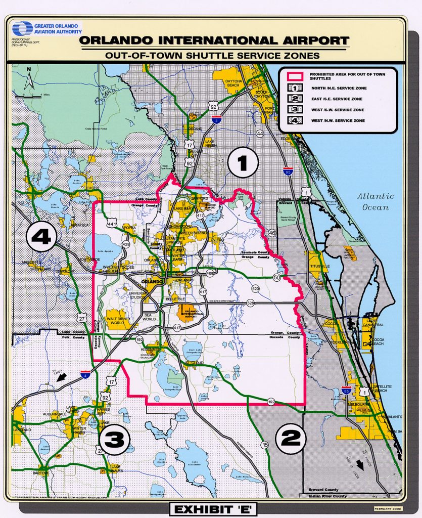
Out of Town Shuttles
Out-of-town shuttles are available on Level 1 (Ground Transportation) of Terminal A (spaces A14-A15), Terminal B (spaces B14-B15), and Terminal C (space C276).
-
Northeast
Flagler & Volusia County
Major Destinations Served:
- Daytona Beach
- Deland
- Deltona
- Flagler Beach
- Ormond Beach
- Palm Coast
Groome Transportation of Florida
(386) 257-5411 -
Southeast
Brevard County & The Beaches
Major Destinations Served:
- Cape Canaveral
- Cocoa Beach
- Kennedy Space Center
- Melbourne
- Miami
- Palm Bay
- Patrick AFB
- Port Canaveral
- Titusville
- Vero Beach
- West Palm Beach
Busy Traveler Transportation
(321) 453-5278Cocoa Beach Shuttle
(321) 631-4144Melbourne Airport Shuttle
(321) 724-1600 -
Southwest
Highlands & Polk County
Major Destinations Served:
- Avon Park
- Clearwater
- Haines City
- Lake Wales
- Lakeland
- Sarasota
- Sebring
- St. Petersburg
- Tampa
- Winter Haven
000 AAA Cruise Line Connection
(321) 250-0009Florida Superior Shuttle
(407) 583-7514 -
Northwest
Alachua, Lake & Marion County
Major Destinations Served:
- Belleview
- Clermont
- Eustis
- Fruitland Park
- Gainesville
- Lady Lake
- Mount Dora
- Ocala
- Silver Springs
- Tavares
- Umatilla
- The Villages
Groome Transportation LLC
(352) 539-9664Shuttleliner of Ocala
(352) 237-9900
Please contact the companies directly to confirm arrival and make reservations
Not all destinations serviced on a regular scheduled basis; contact shuttle operator for details and fares.
Schedules are provided by the ground transportation operators. The Aviation Authority provides this information as a public service and is not responsible for any errors omissions.
Out of town shuttles are prohibited from servicing:
- Walt Disney World
- International Drive
- Universal Studios
- Lake Buena Vista
- Downtown Orlando
- US 192 (extending to US 27)
- Other locations within Orange, Osceola and Seminole counties (see map) For these destinations please refer to our Local Transportation page.
Resort & General Transportation Concessionaire
Mears Destination Services (MDS)
Mears Destination Services (MDS) is the Aviation Authority’s Ground Transportation Concessionaire. It provides ground transportation to many destinations within Orlando and beyond, including Walt Disney World® Resort, via bus, sedans, limousine and shuttle van.
- Resort Transportation: Mears Connect
- Terminal B on Level 1 (Ground Transportation) in spaces B42-B48
- Terminal C on Level 1 (Ground Transportation) in spaces C282-C283
- Train Station on Level 1 (Ground Transportation) in spaces C1-C2
- General Transportation: Mears Destination Services

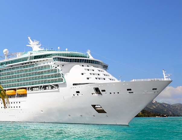
Cruise Transfers
Transportation to Port Canaveral
Some cruise lines offer transportation on the 42 mile route between Port Canaveral and Orlando International Airport, therefore you may wish to check directly with your cruise line.
Transportation is also available through some of our Ground Transportation Permit Holders serving the Port Canaveral area as well as our On-Site Cruise Transfer companies:
Alternatively, please see the Out Of Town Shuttles page of our web site. If you are traveling in a group, you may also wish to review the Local Transportation page as taxis charge per trip, while shuttles charge per person. We also provide a list of Vehicles for Hire which lists companies that are permitted to pick up passengers that have pre-arranged transportation with the company.
Please contact the companies directly regarding fares, schedules and reservations, and enjoy your cruise!
National
Brightline
Brightline guests can enjoy a ride in high-speed, comfortable trains from Orlando International Airport to top destinations in South Florida, with stations in West Palm Beach, Boca Raton, Fort Lauderdale, Aventura, and Miami.

Amtrak
The Amtrak station is approximately 12 miles from Orlando International Airport, and can be accessed via Buses & Taxis or Vehicles for Hire.
Take Lynx bus #11 to Orange Avenue and Columbia Street. The Amtrak station is approximately half a mile from the bus stop, down Columbia Street then left onto Sligh Blvd.
Travel time to Orange & Columbia is approximately 30 minutes, at a cost of $2 Please see the Lynx web site for current details.
Amtrak 1400 Sligh Blvd.
Greyhound
The Greyhound station is approximately 13 miles from Orlando International Airport, and can be accessed via Buses & Taxis or Vehicles for Hire.
Take Lynx bus #11 to North Garland Avenue, then take Lynx bus #25 to 500 John Young Parkway. The Greyhound station is across the road at 555 N. John Young Parkway.
Travel time is approximately 60 minutes, at a cost of $2 Please see the Lynx web site for current details.
Greyhound 555 N. John Young Parkway
Vehicles for Hire
| Company | Phone | Company | Phone | |
| “O” STAR LIMOUSINE | (407) 288-5888 | LIMOCAR INC | (407) 721-1014 | |
| 0-0 A1A OCEAN DRIVE TRANSPORT & LIMO | (386) 226-1111 | Limos Corp | (407) 483-6195 | |
| 1001 Transportation Inc | (407) 946-0011 | Link MCO LLC | (844) 822-2966 | |
| 21st Century Transportation LLC | (321) 746-1477 | LOGIC TRANSPORTATION GROUP LLC | (407) 415-3447 | |
| 2BA LLC | (321) 888-7222 | LP LUXURY TRANSPORTATION LLC | (407) 922-0972 | |
| 2DAYS BEST RIDE | (321) 622-0622 | LRJ TRANSPORTATION, LLC | (407) 881-3378 | |
| 4 Kings Transportation LLC | (321) 261-2363 | Luna Negra Transportation Services LLC | (407) 624-8582 | |
| A & E LUXURY TRANSPORTS LLC | (407) 395-3606 | LUXE CONNECTIONS | (407) 724-7368 | |
| A CAR SERVICE JF INC | (407) 353-0769 | Luxiel Travel & Tours Inc. | (407) 591-9964 | |
| A NIGHT TO REMEMBER LIMOUSINE CORP | (352) 680-0201 | LUXURY RIDES INC. | (407) 493-9477 | |
| A&C Orlando Transportation LLC | (407) 280-2623 | LUXURY TRANSFER CONNECTION LLC | (480) 540-0251 | |
| A-Z DESTINATION TRANSPORTATION LLC | (407) 350-7772 | LUXURY TRANSPORTATION GROUP | (407) 921-1334 | |
| AAA ORLANDO RIDE LLC | (321) 318-3225 | LUXURY TRANSPORTATION SOLUTIONS LLC | (401) 965-6596 | |
| AAWESOME TOWNCAR SERVICE INC. | (321) 229-3230 | M Pabla Corp. | (561) 498-7707 | |
| ACCEL LUXURY TRANSPORTATION LLC | (321) 440-3302 | M.A.CH Corporate Inc. | (305) 781-2328 | |
| ACCESS LINE TRANSPORTATION INC | (407) 517-9386 | M.G.M. TRANSPORTATION GROUP INC | (347) 965-7043 | |
| ACCESS TRANSPORTATION OF ORLANDO INC | (407) 523-1494 | M.H. TRANSPORTATION INC | (407) 948-7809 | |
| ACE | (407) 832-9201 | MAGIC FLIGHT COMPANY | (407) 383-7396 | |
| ACN Signature LLC | (336) 926-1452 | Magical Luxury Shuttles | (407) 404-8831 | |
| Adrece Luxury Transportation LLC | (407) 591-7891 | Magical Orlando Tours | (407) 493-2054 | |
| Advance Ride LLC | (407) 800-3775 | MAINGATE TRANSPORTATION | (407) 870-5553 | |
| AHN LUXURY TRANSPORTATION LLC | (321) 948-1780 | MAJESTIC TRANS | (407) 620-1672 | |
| AHORA LUXURY TRANSPORTATION | (407) 433-8989 | MANITUR | (407) 729-5880 | |
| AJ LUXURY TRANSPORTATION CORP | (407) 914-3655 | MANTON TRANSPORTATION LLC | (774) 240-7593 | |
| ALADDAN TRANSPORTATION, LLC | (407) 619-5060 | Marte Express LLC | (407) 300-1295 | |
| Alafin Luxury Ride | (321) 947-4616 | MARTIN FAYNIK | (407) 342-2727 | |
| ALAMI TRANSPORTATION | (407) 908-1986 | MASTERS CHARTER | (407) 234-2232 | |
| Alan and Alex Management Services, LLC | (754) 216-1774 | MASTERS VIP | (407) 234-2232 | |
| Alberto’s Transportation Service LLC | (407) 508-0154 | MCA TRANSPORTATION INC | (407) 352-9464 | |
| ALJ55 SERVICES LLC | (602) 367-1916 | MCO TRANSFERS | (407) 679-9080 | |
| ALJOA 1 TRANSPORTATION LLC | (646) 591-9349 | MERCADO TRANSPORTATION LLC | (407) 683-1331 | |
| All Star Tours | (407) 717-4656 | Merie LLC | (321) 245-8147 | |
| ALONA BATRA LLC | (844) 626-7433 | METRO | (407) 760-2004 | |
| AM PM Trans, Inc. | (407) 832-2882 | METRO TRAVEL | (407) 209-7722 | |
| Amazing Grace Carrier LLC | (407) 676-1291 | MIAMI BEACH LUXURY TRANSPORTATION | (407) 401-4000 | |
| AMAZING PRODUCTIONS AND MORE LLC | (321) 888-5010 | Michel Hanna Rouhana | (407) 341-3354 | |
| American Eagle 1 LLC | (331) 425-3445 | Miguel Transportation | (407) 202-4271 | |
| AMERICAN EAGLE EXCURSION TOURS INC | (407) 556-5414 | Millennium Group USA Inc. | (407) 361-1924 | |
| AMERICAN ELITE TRANSPORTATION LLC | (407) 398-2068 | MJ Chauffeur LLC | (347) 933-3433 | |
| AMERICAN EXECUTIVE TRANSPORTATION | (407) 342-0792 | Mo Luxury LLC | (917) 412-5478 | |
| AMERICAN TOWNCAR SERVICES | (321) 436-6878 | Modern Transportation Services Inc (MTS) | (407) 969-6448 | |
| AMIGO EXPRESS LIMO | (407) 793-1990 | MOHAMED ESTAFANO SABRO | (407) 810-5270 | |
| ANGELS LUXURY TRANSPORTATION | (407) 666-3932 | MSB DESTINATIONS LLC | (407) 432-1996 | |
| ANJ TRANSPORTATION LLC | (407) 738-0788 | MY ORLANDO RIDE , LLC | (407) 446-7677 | |
| APOLLO’S CHARIOTS INC. | (407) 490-3313 | MY PREMIER TRANSPORTATION LLC | (203) 482-7500 | |
| AREO TRANSPORTER | (407) 705-4313 | MYC TRANS LLC | (407) 455-2540 | |
| ARISTOCRAT | (407) 898-3446 | MYTOWNCAR, LLC | (407) 310-6978 | |
| Arrive in Luxury | (407) 329-6063 | NAFIZ TRANSPORTATION LLC | (407) 569-5436 | |
| ARROYO TRANSPORTATION | (407) 275-6500 | NAIRN | (407) 600-2758 | |
| AS LUXURY TRANSPORTATION LLC | (321) 947-5644 | Neil Transportation Inc | (917) 528-0521 | |
| Ashar Arfeen LLC | (407) 733-9037 | Nero Luxe | (240) 882-8512 | |
| ATLAS TRANSPORTATION SERVICES | (407) 446-5865 | NETDUKE TECH LLC | (415) 309-9712 | |
| AUTANA ELITE TRANSPORTATION | (407) 538-5330 | NOEL TRANSPORTATION | (518) 894-1945 | |
| AVALON – ORLANDO, FL | (407) 256-5044 | NONA EXECUTIVE TRANSPORTATION LLC | (407) 402-6499 | |
| AVIS LIMO FL INC | (888) 778-1964 | NORAYA TRANS | (407) 785-7884 | |
| AWAY WE GO LLC | (281) 772-4106 | NORIS TRANSPORTATION | (407) 240-4533 | |
| Aybar Transportation Corp | (407) 990-2766 | NYC Lux Transportation LLC | (917) 601-9464 | |
| AYDEN TRANSPORTATION | (407) 705-4175 | OCS | (407) 470-6008 | |
| Azher Qureshi | (407) 256-7378 | Olive Transp LLC | (321) 977-3125 | |
| BACKSTAGE TRANSPORTATION INC | (321) 945-3506 | ONE OF A KIND LUXURY TRANSPORTATION LLC | (407) 402-7648 | |
| BARR’S TRANSPORTATION INC | (904) 642-1662 | ORANGE TOURS & TRANSPORTATION,LLC | (407) 435-9720 | |
| BELLA EXECUTIVE TRANSPORTATION LLC | (407) 460-2037 | ORIGINAL GROUND BREAKERS CO-OP INC | (888) 999-7058 | |
| BENNS LUXURY RIDE LLC | (407) 756-4008 | ORL EXECUTIVE SERVICE LLC | (321) 417-0593 | |
| BEST COAST | (212) 960-1613 | ORLAND CARSERVICE LLC | (386) 871-1513 | |
| BEST LUXURY TRANSPORTATION INC | (407) 505-5757 | ORLANDO AIRPORT TOWNCAR, INC | (407) 754-8166 | |
| Big Bargain Transportation Inc. | (407) 451-8444 | Orlando Airport Transportation Pick up a | (321) 696-2705 | |
| Black Car Transportation LLC | (305) 586-6304 | ORLANDO BLACK CAR INC | (321) 900-5929 | |
| BLACK CHARIOT, LLC | (407) 668-8880 | Orlando Connect LLC | (407) 242-5387 | |
| BLACK DIAMOND LUXURY TRANSPORTATION LLC | (407) 516-9595 | ORLANDO DELUX SIGNATURE LLC | (321) 948-3791 | |
| Black Karz Services Inc | (407) 284-7800 | ORLANDO DESTINATION & TRAVEL LLC | (407) 748-7277 | |
| BLACK LUX TRANSPORTATION | (321) 214-1000 | ORLANDO EAGLE TRANSPORTATION LLC | (407) 480-6694 | |
| BLUE HORIZON EXPRESS INC | (407) 575-5277 | ORLANDO EXECUTIVE CHAUFFEUR TRANSPORTATI | (407) 360-6101 | |
| BOOK CENTRAL FLORIDA LLC | (321) 666-3642 | ORLANDO LUXE TRANSPORTATION LLC | (407) 446-1050 | |
| BOOK TRANSPORTATION | (407) 516-3439 | Orlando Luxury Ride Services LLC | (407) 267-6666 | |
| Bravo Travel Inc. | (407) 408-1141 | Orlando Luxury Transport Inc | (407) 375-4403 | |
| BREVARD EXECUTIVE TRANSPORTATION | (321) 723-9322 | ORLANDO LUXURY TRANSPORTATION | (407) 692-6430 | |
| BRUCE MARSHALL TRANSPORTATION | (407) 342-6717 | Orlando Magical Rides LLC | (321) 682-0525 | |
| C & J XTREME SERVICES, LLC | (347) 777-1464 | Orlando Magical Transportation Corp | (407) 946-0783 | |
| C&M Executive Transportation | (312) 887-0343 | ORLANDO ON WHEELS LLC | (407) 342-1122 | |
| C’S LUX | (786) 222-0895 | Orlando Premiere Transportation | (407) 952-4431 | |
| CANANI TRANSPORTS LLC | (407) 454-2070 | Orlando Pride Transportation | (407) 718-0052 | |
| CAPE CANAVERAL TRANSPORTATION | (321) 431-1812 | ORLANDO RIDE | (407) 948-4353 | |
| CAPRI TRANSPORTATION LLC | (352) 268-2609 | ORLANDO SEDAN EXPRESS | (407) 344-5566 | |
| Cast and Crew Transportation | (407) 947-6670 | ORLANDO STYLE | (407) 492-4382 | |
| CEDAR TRANS LLC | (407) 592-8483 | ORLANDO SUN TRANSPORTATION | (407) 508-1927 | |
| Cetoune Geffrard Transportation | (407) 485-5274 | ORLANDO TRANSFER LLC | (407) 433-5599 | |
| CHARLES ROSEAU TRANSPORTATION LLC | (954) 849-4801 | ORLANDO TRANSPORTATION & TOURS INC | (847) 875-3559 | |
| CHEAPO TRANSPORTATION | (407) 680-8804 | ORLANDO TRANSTOUR INC. | (407) 860-3378 | |
| CHECKERS TRANS GROUP INC | (617) 697-7320 | OT Destination LLC | (321) 318-7890 | |
| CIAO!!! TRANSPORTATION LLC | (407) 608-9137 | Ozi Transportation | (321) 408-9696 | |
| CINA TRANSPORTATION | (407) 766-1969 | Panda Global Tours | (321) 460-9196 | |
| City Transportation LLC | (407) 509-3019 | PARK AVENUE TRANSPORTATION | (407) 668-0850 | |
| CLASSIC FLORIDA TOURS INC | (407) 456-0330 | PDA CENTRAL FL CORP | (407) 766-8271 | |
| CLASSIC LUXURY TRANSPORTATION | (646) 546-7817 | PEGASUS PROFESSIONAL TRANSPORTATION LLC | (407) 697-1122 | |
| CLASSIC VIP TRANSPORTATION | (772) 778-7590 | PERSONAL ASSISTANT SERVICES LLC | (407) 592-5898 | |
| CMC LUXURY CORP. | (347) 948-1447 | PETRA ORLANDO TOURS LLC | (407) 399-1282 | |
| Comfort Fleet FLorida LLC | (401) 837-1501 | PG TRANSPORTATION SERVICE LLC | (407) 953-6735 | |
| Comfortphil Transportation LLC | (321) 447-1033 | PINNACLE87 LLC | (407) 913-9605 | |
| CORPORATE WORLDWIDE TRANSPORTATION INC | (407) 318-4590 | PLATINUM TRANSPORTATION,INC | (407) 492-8888 | |
| CORTRANS SHUTTLE SERVICE | (407) 446-3896 | POMPERMAYER DELIVERY LLC | (407) 470-8746 | |
| CROSSLINK TOURISTIC SERVICES | (407) 885-6666 | PORT CANAVERAL TRANSIT LLC | (321) 480-7311 | |
| Crowdsourcing LLC | (321) 947-6044 | PORT TO PORT SHUTTLES LLC | (407) 747-1447 | |
| CROWN AIRPORT TRANSPORTATION LLC | (407) 251-1224 | PR Luxury Transportation LLC | (321) 946-5360 | |
| CRUISE CONTROL TRANSPORTATION | (407) 837-0811 | PRECISION | (407) 888-2908 | |
| CRYSTAL TRANSPORT | (561) 262-8352 | Prestige Luxury Transportation | (407) 913-2929 | |
| D & S Executive Transport Service | (407) 923-5092 | Prime Mobility | (407) 608-8921 | |
| D’Elegance Transport | (786) 678-3655 | PRIME TRANSPORTATION SERVICES INC | (321) 230-7639 | |
| Dalem’s Luxury Ride LLC | (786) 202-9750 | Professional Drivers Network LLC | (561) 781-1518 | |
| DANICA TRANSPORTATION INC | (407) 879-2220 | PROMPT TRANS LLC | (516) 851-7999 | |
| DAVENPORT TRANSPORTATION LLC | (407) 267-6267 | PRONTO LIMOUSINE SERVICE INC | (352) 427-2942 | |
| DDD ELITE RIDE LLC | (407) 404-4771 | QUICK TRANSPORTATION | (407) 354-2456 | |
| DELTA VIP TRANSPORTATION LLC | (407) 968-6533 | QUICKSILVER TOURS AND TRANSPORTATION INC | (407) 436-4940 | |
| DELUXRIDE INC. | (407) 668-5866 | QUORA 71 INC | (407) 690-1210 | |
| DERIN TRADING LLC | (407) 437-2829 | R & P LUXURY | (646) 372-2510 | |
| DESTINATION MCO INC | (407) 422-2522 | R&S LUXURY SEDAN SERVICE LLC | (813) 785-3920 | |
| DEVON TRANSPORTATION | (321) 946-4791 | RAMADA TRANSPORTATION | (321) 278-7274 | |
| DFinest Executive Car Service | (347) 873-3655 | Randy Transport LLC | (907) 267-9391 | |
| DG TRANSPORTATION | (631) 513-3937 | RAPHA TRANSPORTATION CORP | (407) 579-3699 | |
| Divinity One Multiservices LLC | (407) 480-6217 | REYMAR LUX BLACK SERVICES LLC | (407) 745-9103 | |
| Donovan’s Limousine LLC | (321) 806-3060 | RJ LUXURY TRANSPORTATION | (407) 955-6973 | |
| DREAMLAND TOURS & TRANSPORTATION INC | (407) 490-7786 | ROAD RUNNER SHUTTLE LLC | (321) 506-9789 | |
| E & J Deluxe Transport LLC | (786) 877-7959 | Royal Luxury Transportation, Inc | (904) 899-3679 | |
| E-Z TIME TRANSPORTATION LLC | (407) 509-8586 | ROYAL RIDER LLC | (407) 962-7597 | |
| Eagle VIP | (407) 462-5754 | ROYAL TRANSPORTATION GROUP, LLC | (407) 855-2555 | |
| ELEGANCE BLACK CAR LLC | (407) 807-8959 | RP TOURS | (321) 231-2150 | |
| ELEX | (407) 435-7008 | S&JD Transportation “LLC” | (340) 998-8409 | |
| Eliane Transportation LLC | (407) 683-6659 | S.E.R. Transportation LLC | (407) 492-4583 | |
| Epic Private Hire LLC | (863) 637-5525 | SAFE LANE TRANSPORTATION LLC | (407) 799-7575 | |
| Essence Transportation LLC | (407) 702-4868 | SAM GOLDEN TOURS LLC | (347) 484-5480 | |
| EVERGREEN EXPRESS TRANSPORTATION, LLC | (407) 338-0181 | SAM TRANSIT LLC | (201) 888-3932 | |
| EXCALIBUR TRANSPORTATION SERVICE INC | (407) 290-9448 | Sara Transportation LLC | (407) 600-2467 | |
| EXCELSIOR CHAUFFEURED TRANSPORTATION | (407) 267-5696 | SB&B Transportation LLC | (407) 376-3711 | |
| EXECUTIVE CHAUFFEURS LLC | (407) 928-9127 | SCREW BEING LATE TRANSPORTATION LLC | (770) 355-6068 | |
| EXECUTIVE LIVERY SERVICE LLC | (407) 353-5585 | SERVICLASS CORP | (321) 314-5526 | |
| Express Lux Transportation Corp | (786) 442-5086 | SHARIF TRANSPORTATION INC | (321) 310-7626 | |
| EZ Luxury Transportation LLC | (407) 973-5342 | SHOWTIME TRANPORTATION SERVICES | (407) 699-6060 | |
| EZZI TRANSPORTATION INC. | (407) 924-2755 | SIGNATURE LUXURY TRANSPORTATION GROUP LL | (321) 297-3986 | |
| FABO CRUISE TRANSPORTATION LLC | (407) 600-4447 | SIGNATURE TRANSPORTATION SERVICE INC | (407) 765-2058 | |
| FANCY | (407) 716-0785 | SK VIP Transportation Inc. | (321) 202-9865 | |
| FINEST TRANSPORTATION AND EXECUTIVE SERV | (646) 210-0767 | SKL TRANSPORTATION LLC | (407) 473-4483 | |
| FIRST AMERICAN TRANSPORT LLC | (407) 460-7673 | SKYHOP GLOBAL LLC | (954) 314-0931 | |
| FIRST ORLANDO TRANSPORTATION | (407) 529-9362 | SKYLINE DESTINATION MANAGEMENT INC | (407) 217-5900 | |
| FIVE TRANSPORTATION LLC | (689) 252-1001 | SMART SHUTTLE LINE INC | (772) 343-0217 | |
| FL SPACE COAST RIDE INC | (407) 970-7741 | SNACK MANIA LLC | (407) 543-7496 | |
| FL TOURS TRANSPORT LLC | (407) 857-9606 | SONY & MAGLONA MULTI SERVICES LLC | (407) 283-2617 | |
| FLEET TRANSPORTATION | (407) 655-8273 | SOUTHERN ELEGANCE LIMOUSINES 2 | (321) 436-3474 | |
| FLEETWOOD | (407) 484-5253 | SPACE COAST PRIVATE DRIVER | (321) 345-9055 | |
| FLM UNLIMITED VENTURES LLC | (407) 844-6123 | SPDB Transportation LLC | (407) 234-2115 | |
| Florida Black Car Service LLC | (386) 333-2482 | SPL TRANSPORTATION SERVICES LLC | (407) 928-4204 | |
| FLORIDA LIVERY | (407) 709-2534 | Splendor Transit LLC | (407) 770-4440 | |
| Florida Luxury Rides Transportation LLC | (407) 803-3733 | Stagecoach Orlando | (407) 437-9113 | |
| FLORIDA TOWNCAR SERVICE | (407) 277-5466 | STAGECOACH TRANSPORTATION LLC | (352) 854-6642 | |
| FLORIDA TRANSPORT GROUP, INC. | (407) 406-4680 | STANDARD TRANSPORTATION INC | (407) 721-8013 | |
| FMTT | (407) 501-6163 | Stanley Luxury Transportation LLC | (407) 373-4540 | |
| FOX IN BLACK CAR SERVICE LLC | (863) 330-2116 | Star Prime LLC | (407) 341-6026 | |
| FQ TRANSPORTATION LLC | (407) 625-2402 | STARLINE | (407) 679-8844 | |
| FSE Luxury Transportation LLC | (407) 403-4683 | Stars Lux Transport | (646) 577-6356 | |
| GARDEN TOURS & TRANSPORTATION INC | (407) 240-4500 | STARWOOD TRANSPORTATION LLC | (407) 690-0196 | |
| GATORS TRANSPORTATION INC | (407) 501-3333 | Stellar Luxury Transportation LLC | (347) 720-4393 | |
| GEARFUSION, LLC | (407) 457-9253 | SULTAN TRANSPORTATION LLC | (407) 953-7971 | |
| Gem Luxury Services LLC | (407) 697-8674 | SUNNY’S TRANSPORTATION INC | (321) 942-2644 | |
| GJL Transportation LLC | (407) 451-9255 | SUNRISE FLORIDA TRANSPORTATION, INC | (407) 709-8769 | |
| GLOBE TECH TRANSPORTATION | (407) 744-5408 | Sunstate Transport | (407) 601-7900 | |
| Glory Elite Transportation LLC | (407) 431-5276 | SUNWAY TRANSPORTATION INC | (407) 914-1017 | |
| GMAR Lux Transport LLC | (407) 506-2870 | Super Express Transportation LLC | (321) 989-8001 | |
| GO 2 MCO Transportation LLC | (689) 233-1825 | SUPERB | (407) 352-1010 | |
| GO-BY TRANSPORT LLC | (407) 800-6599 | Supreme Transportations Orlando LLC | (407) 820-0072 | |
| God’s Grace Multi-Services LLC | (321) 430-9376 | SUV-EXPRESS TRANSPORTATION LLC | (407) 496-8958 | |
| Good Ride Express | (321) 315-1934 | Taso.s Transport & Tours Inc. | (321) 442-4787 | |
| GREENBOW TOUR INC | (407) 353-3005 | Tatishvili Company, L.L.C. | (347) 543-4953 | |
| GREG TRANSPORTATION SERVICES LLC | (561) 762-3807 | TC TRANSPORTATION SERVICES | (772) 581-0851 | |
| Grove Street Transportation | (727) 804-0690 | TEPUY | (407) 460-2737 | |
| Guzman4Business L.L.C. | (718) 928-5126 | The Black Key Luxury Transportation LLC | (352) 242-8867 | |
| GW CHAUFFEURED SERVICES LLC | (407) 341-7822 | The Genie Transportation Services, LLC | (917) 477-9143 | |
| H & O TRANSPORTATION | (407) 873-9270 | THE MAGICAL EXPRESS | (985) 789-7654 | |
| HANY TRANS LLC | (407) 346-2277 | The One Transportation Inc. | (407) 641-7242 | |
| HAPPY | (407) 856-1280 | The Palm Elite LLC | (321) 318-5955 | |
| Harjinder Singh | (516) 450-0585 | THERMOLICE SERVICES | (407) 222-0539 | |
| Hayden VIP Transport | (407) 271-7142 | TIFFANY TOWNCAR LLC | (407) 370-2196 | |
| Heisler Group | (407) 565-2224 | Timeless VIP LLC | (689) 200-5721 | |
| HOLLYWOOD TRANSPORTATION | (321) 777-9009 | TITIF TRANSPORTATION LLC | (407) 484-2437 | |
| Home James Orlando Transportation | (407) 694-6198 | Toledo Executive Transportation LLC | (321) 440-7373 | |
| HOT RAYZ LIMOUSINES | (321) 412-2202 | TONY’S BLACK CAR INC. | (347) 475-9162 | |
| Ibex Towncar Service Inc | (407) 523-2999 | TOO EASY SOLUTIONS LLC | (407) 693-1153 | |
| IMPERIAL TRANSPORTATION LLC | (321) 231-8680 | TOP NOTCH CHAUFFEURS LLC | (407) 924-4837 | |
| IMPERIUM LUXURY TRANSPORTATION | (407) 692-1065 | TOWN CAR KING LLC | (407) 417-7183 | |
| INNOVA BC GROUP | (321) 318-3779 | TRANSLUX USA | (407) 335-3170 | |
| INTEGRITY TRANSPORTATION INC | (407) 709-5412 | TRANSPORTACION SEGAMEL LLC | (786) 397-9513 | |
| INTERPLEX TRANSPORTATION | (407) 435-6293 | TRAVEL RITE, LLC | (407) 376-0045 | |
| J & J TRANSPORTATION 413, LLC | (321) 324-8972 | TREASURE COAST RIDES | (772) 933-6057 | |
| J.G.F. | (407) 222-3354 | TRIPLE A TRANSPORTATION LLC | (407) 910-5037 | |
| JANA TRANS LLC | (407) 334-3819 | TRIPLE CROWN VALET INC | (407) 660-0060 | |
| JAYBEE TRANSPORTATION LLC | (718) 514-0152 | TRIPLE TREE TRANSPORTATION LLC | (407) 289-7810 | |
| JB Transportation | (407) 538-3904 | TROPICAL TOURS & TRANSPORTATION INC. | (407) 492-0899 | |
| JCABRERA TRANSPORTATION LLC | (407) 427-6768 | TROPICAL TRANSPORTATION SERVICE LLC | (386) 281-3260 | |
| JEFFSO TRANSPORT LLC | (347) 317-3334 | TUCKER TRANSPORTATION | (863) 293-9559 | |
| JERUSALEM TRANSPORTATION LLC | (407) 738-6240 | TURINI LLC | (201) 618-5024 | |
| JF Elite Transportation | (321) 279-0629 | TUXEDO | (407) 450-1400 | |
| Jimp LLC | (646) 463-9326 | TY Transportation LLC | (804) 304-4609 | |
| JINO SERVICES | (407) 844-3848 | U Cruise Orlando Transportation LLC | (800) 867-4659 | |
| JLS EXCLUSIVE TRANSPORTATION INC | (407) 460-7511 | UB TRANSPORTATION LLC | (321) 402-8265 | |
| Joa Transportation LLC | (917) 650-2819 | ULTIMATE TOWN CAR LLC | (407) 844-3580 | |
| Job Transport of Florida LLC | (407) 837-5656 | UNITED TRAVEL LLC | (407) 486-8812 | |
| JOBO TRANSPORTATION | (407) 346-9415 | UNIVERSAL | (407) 342-8888 | |
| JORQUIN TOURS AND TRANSPORT LLC | (407) 497-2302 | UPSCALE TRANSPORTATION, LLC | (407) 507-6979 | |
| JOS Luxury Ride | (407) 913-3904 | US EAGLE TOUR, LLC | (407) 202-7394 | |
| JR LUXURY TRANSPORTATION INC | (321) 977-3333 | V.I.P LUXURY TRANSPORTATION INC | (407) 463-7060 | |
| JRD Transportation Services | (917) 686-1758 | VANSTAR TRANSPORTATION LLC | (407) 797-8687 | |
| JuJu Transportation Inc. | (321) 419-9444 | VANXL LLC | (321) 210-6175 | |
| JULES SUPREME LUXURY TRANSPORTAION | (340) 998-1067 | Varsity Transportation Inc | (407) 486-1836 | |
| K F TRANSPORTATION | (407) 483-6323 | VAV | (352) 241-2000 | |
| Kadopam, LLC | (407) 488-0189 | VELLANKI LUXURY TRANSPORTATION LLC | (407) 334-4345 | |
| KAI TRANSPORTATION LLC | (407) 592-9151 | VIA TRANSPORTATION INC | (407) 747-3933 | |
| KEITH’S LUXURY TRANSPORTATION | (407) 709-2196 | VILLAGE AIRPORT VAN | (352) 241-2000 | |
| KHANDOKAR & SONS INC | (407) 953-3584 | VIP CHAUFFEUR LLC | (617) 794-3920 | |
| KINGDOM CAR SERVICE | (689) 777-1694 | VIP EXPRESS TOURS, INC | (407) 624-9795 | |
| Klass Luxury Transportation LLC | (407) 394-3672 | VIP LUXURY CAR SERVICE LLC | (516) 424-3990 | |
| KnightLine ExecutiveTransport LLC | (786) 674-5612 | VIP TRANSPORTATION GROUP LLC | (407) 822-7755 | |
| Konnect Me Rapid Transportation LLC | (407) 338-6412 | VISTA TRANSPORTATION INC | (407) 943-4920 | |
| KPS1 TRANSPORTATION LLC | (407) 731-6973 | WANO LUXURY TRANSPORTATION | (321) 430-9245 | |
| KSA DESTINATION MANAGEMENT INC | (407) 256-5627 | We Drive You Fly LLC | (407) 928-1135 | |
| L & L Luxury Transportation LLC | (407) 719-1748 | WHEELERS LUXURY TRANSPORTATION INC | (407) 273-2349 | |
| Lake Transportation Services, LLC | (407) 363-3500 | WIN STAR TRANSPORTATION | (407) 832-3427 | |
| LANIER TRANSPORTATION LLC | (407) 259-3031 | WINTER PARK CAR TRANSPORTATION LLC | (407) 574-1797 | |
| LEE CAR SERVICE ORLANDO LLC | (321) 947-1188 | WORLD’S PRODUCTION INC | (407) 881-5710 | |
| LEEO LLC | (407) 557-0477 | WORKMAN TRANSPORTATION CO | (352) 259-9398 | |
| Lenox Transport | (407) 308-2803 | Worldgate Transportation Inc. | (407) 286-8220 | |
| LEON’S SUV, INC | (407) 470-3646 | XCLUSIVE LUX VIP | (407) 655-8635 | |
| Leopard Transport of Central FL LLC | (866) 204-4000 | XDS Empowerment LLC | (407) 383-1640 | |
| Levern Group LLC | (407) 919-3942 | YMG Transportation LLC | (267) 957-6867 | |
| LIMO ORLANDO, LLC | (407) 477-7724 | YOR Services Transportation LLC | (407) 460-9378 |